Le Pont du Nord: narrative of an identification

Five minutes into Le
Pont du Nord, after a display of locational exactitude across different
parts of Paris – including, on the one side, distinctive lion statues
recognisable to historians of nineteenth-century French civic sculpture, and to
anyone with his copy of Frédéric
Tan’s Paris: 600 sculptures à ciel ouvert
(2005), and on the other a shot of a sign reading place Denfert
Rochereau –, a character (Marie) moves from this last location across a cut
into a small square, where she sits and writes a postcard. The postcard carries
a picture of the Arc de Triomphe, and she addresses it to a friend incarcerated
in the Prison de la Santé (which is nearby, apparently, a little to the east of the place
Denfert-Rochereau).
The sequence lasts just over a minute, and the next sequence features the same character, postcard in hand, attempting to post it, somewhat incongruously, into a shop’s letterbox, untoward behaviour that suggests more generally disorderly conduct.
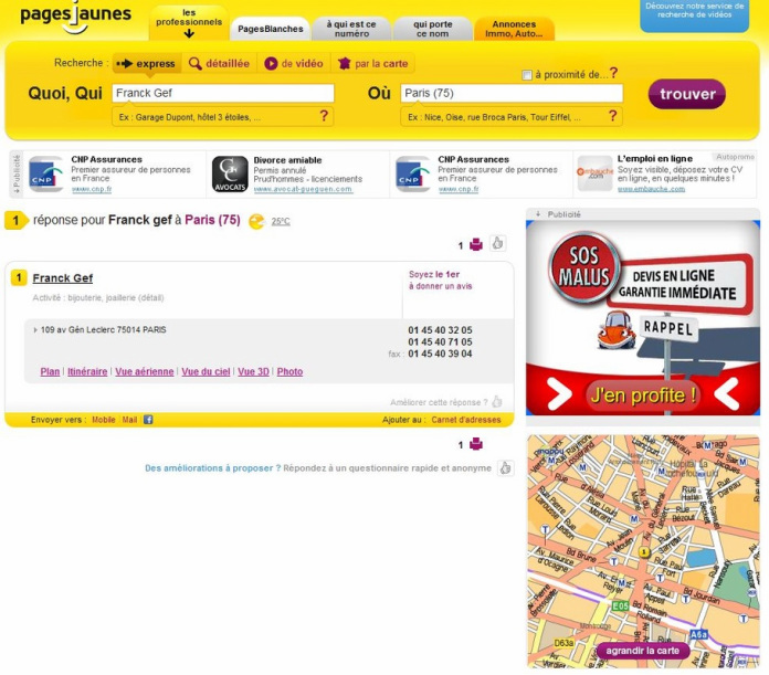
The two sequences each side of the postcard writing scene are easily localised and topographically coherent. The place Denfert-Rochereau is identifiable by its signage and by its lion; the corner of the rue Sarrette and the avenue Général Leclerc again by signage, including the name of the shop, ‘Franck Gef, bijoutier’ (the pages jaunes tell us that the shop is still there).
The sequence lasts just over a minute, and the next sequence features the same character, postcard in hand, attempting to post it, somewhat incongruously, into a shop’s letterbox, untoward behaviour that suggests more generally disorderly conduct.
The two sequences each side of the postcard writing scene are easily localised and topographically coherent. The place Denfert-Rochereau is identifiable by its signage and by its lion; the corner of the rue Sarrette and the avenue Général Leclerc again by signage, including the name of the shop, ‘Franck Gef, bijoutier’ (the pages jaunes tell us that the shop is still there).
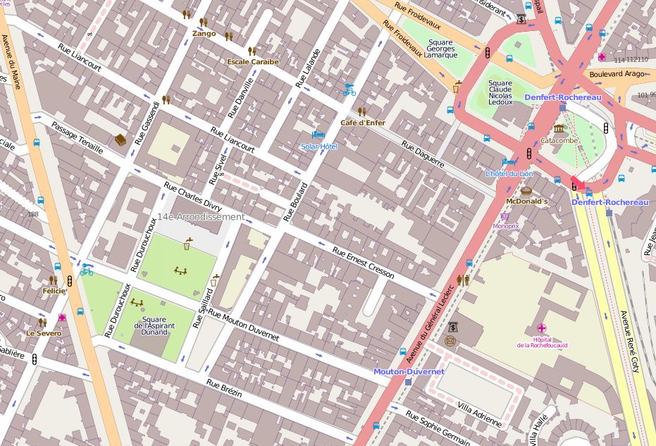
Logically, then, or more exactly topo-logically, the
‘postcard in the square’ scene should take place somewhere between the place Denfert-Rochereau
and the jeweller’s shop. To confirm this logic, I visited, through Google Maps,
every public square between and in the immediate vicinity of these two locations.
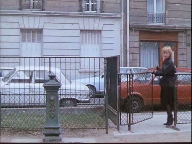
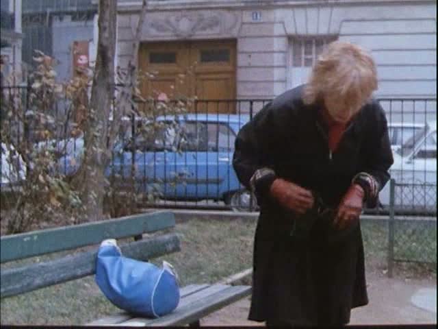
I should say what exactly I was looking for. The film gives three identifiable details: the fence and gate of the square; the square’s
furniture, specifically the positioning of the bench and a water-hydrant in
relation to the gate; and the look of the buildings on the street running alongside
the square. Of these, the last is the most likely to bring results, since
Google’s Street View in Paris allows us to see every building on streets
accessible to motor vehicles (problems arise only in trying to identify private
streets or streets only accessible to pedestrians, such as the stairways in Belleville and Montmartre). So I fixed in my mind what is shown of the
building’s doorway and façade, including the number of windows (3), the pattern of
the facing, the shape of the moulding above the door, the shape and style of the
door itself. There is also a number ‘11’ visible on the building, but given that
the film will later affix wrong numbers to buildings according to the jeu de l’oie being played, I wasn’t
going to assume that this number here was authentic.
I didn’t manage to find the square, for which there were at
least three possible explanations:
A/ I had simply not been looking properly;
B/ it was no longer there, having been built over in the years between the shooting of the film (1980) and the taking of the Google pictures (2009);
C/ the square was not logically localised, but was a part of what François Penz (2008) has called the ‘creative geography’ of Rivette’s film, meaning that it could be anywhere within the city limits, regardless of where Marie is before or after the sequence.
In response to suggestion A:
since Google’s ‘map’ mode doesn’t show green spaces as green, I had surveyed the territory in ‘satellite’ mode, but there the difficulty lay in differentiating between public and private green space:
From the sequence we can see that a street passes alongside
the square (a one-way street about three cars wide), and on the satellite
picture roads are marked, so it is possible to pick out possible squares, but
easy to miss one or two. I turned instead to OpenStreetMap, which does show most
green spaces as green, though in the example here the very green gardens of the
Villa Adrienne are shown only as grey:
Hard-copy street maps do tend to show all relevant greenery,
but like OpenStreetMap they don’t offer a photographic streetview, so I found
myself switching to Google to see each time if a green space was actually the
square from the film. I still couldn’t find it.
|
Suggestion B: in the designated territory (a large stretch of the 14th arrondissement) there are several post-1980 developments, mostly residential, which may well have gone up at the expense of a small public square or garden. Accordingly I used a hard-copy map of Paris from the time of the film, and checked every instance of marked greenery against the modern map. There seems to have been no public square lost to redevelopment in the area concerned.
Suggestion C: increasingly the most likely option, but the idea of examining closely the streets around every one of Paris’s 300 or so squares was daunting. I began with the Mairie de Paris’s website, which lists squares by arrondissement, beginning with those adjacent to the 14th, then with those where other scenes of the film are situated. For example, a little earlier, when Marie was in the place Denfert-Rochereau, there was an inserted shot of a statue in the square Montholon, across Paris in the 9th, the vicinity of which would be the location for the film after leaving the 14th. But neither the square Montholon nor any other in the 9th corresponded to the one I was looking for. |
 |
Eventually, going from arrondissement to arrondissement, I thought I’d found a perfect match at number 8 place du Puits de l’Ermite, in the 5th. As you can see, the shape of the door matches, the lines on the facing are identical, and the moulding above the door is similar. Only similar, however, and the building in the film has three windows to the right of the door, whereas number 8 place du Puits de l’Ermite only has two. This is, sadly, not the same building:
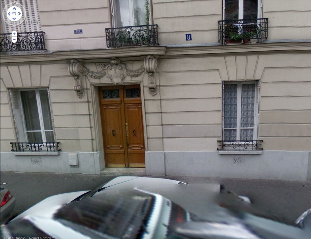
That there be two such buildings of similar aspect in Paris
is not surprising: my square-by-square search has taught me that late
nineteenth-century residential buildings tend to conform to a basic set of
models, with sometimes only very slight variations.
When I reached the end of the list of squares without finding a match, I decided to follow a different piste. If the building on the place du Puits de l’Ermite looked so much like the one I was looking for, then perhaps that was because the two were designed by the same architect. It is very common to find the architect’s name inscribed on the front of such buildings in Paris, and the zoom facility of Google’s street views allowed me to pick out the name on the place du Puits de l’Ermite building: Moreau. As I learned from parisenconstruction, a site listing permissions to build granted by the Paris authorities between 1876 and 1939, there were several architects of that name at work in the period, but the most prolific by far was Jean-Mathurin Moreau (born 1854), son of the sculptor Mathurin Moreau. I examined every still extant building attributed to him from the list of permissions granted, familiarised myself thoroughly with his not too various styles (including several buildings in style similar to the one I was looking for), I crossed Paris in all directions, following an alphabetical rather than topographical order, but I still didn’t find my match.
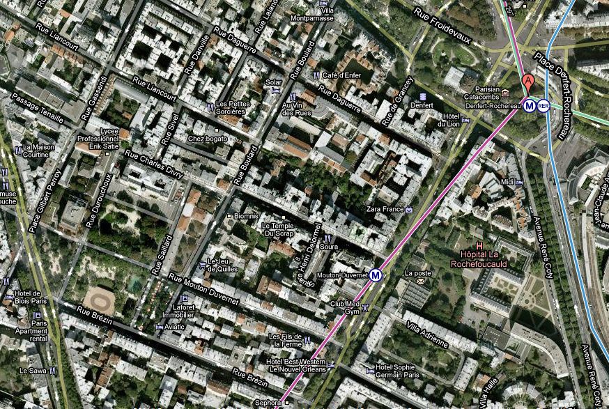
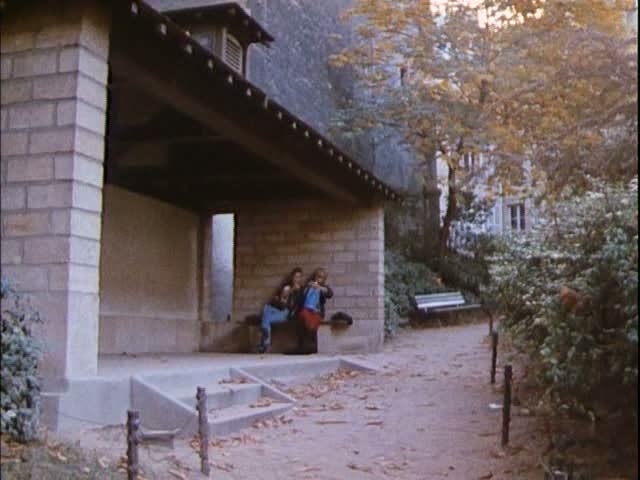
I had no choice but to repeat the square-by-square search, in case I had missed something. This time I consulted a different list, not that of the Mairie de Paris but the list on Wikipedia, simply, and started through the squares alphabetically, rather than by arrondissement. This didn’t take as long as before, because Paris’s seventy-third square alphabetically, the first beginning with the letter D, turned out to be the one I wanted. Here is the Google Street View of number 11 place Dampierre-Rouvet, just off the quai de la Gironde, by the canal Saint Denis, in the 19th arrondissement.
When I reached the end of the list of squares without finding a match, I decided to follow a different piste. If the building on the place du Puits de l’Ermite looked so much like the one I was looking for, then perhaps that was because the two were designed by the same architect. It is very common to find the architect’s name inscribed on the front of such buildings in Paris, and the zoom facility of Google’s street views allowed me to pick out the name on the place du Puits de l’Ermite building: Moreau. As I learned from parisenconstruction, a site listing permissions to build granted by the Paris authorities between 1876 and 1939, there were several architects of that name at work in the period, but the most prolific by far was Jean-Mathurin Moreau (born 1854), son of the sculptor Mathurin Moreau. I examined every still extant building attributed to him from the list of permissions granted, familiarised myself thoroughly with his not too various styles (including several buildings in style similar to the one I was looking for), I crossed Paris in all directions, following an alphabetical rather than topographical order, but I still didn’t find my match.
I had no choice but to repeat the square-by-square search, in case I had missed something. This time I consulted a different list, not that of the Mairie de Paris but the list on Wikipedia, simply, and started through the squares alphabetically, rather than by arrondissement. This didn’t take as long as before, because Paris’s seventy-third square alphabetically, the first beginning with the letter D, turned out to be the one I wanted. Here is the Google Street View of number 11 place Dampierre-Rouvet, just off the quai de la Gironde, by the canal Saint Denis, in the 19th arrondissement.
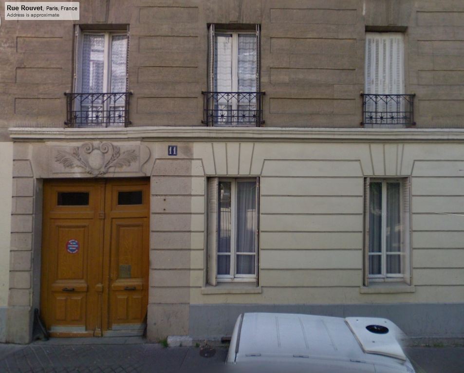
(Number 11 rue Rouvet is not by Jean-Mathurin Moreau. It is
listed with the remark ‘pas d’architecte’, and attributed only to Bazangeon,
i.e. François-Joseph Bazangeon, an ‘entrepreneur de travaux publics’ based in
the nearby rue de Joinville.)
There are some remarkable instances of creative geography in Rivette’s film. At one point the two protagonists are on a street in the 13th arrondissement, in the South East of Paris, and one of them points ahead to ‘l’Etoile’; by the next shot they have moved to the North West, to the foot of the Arc de Triomphe in the place de l’Etoile. As François Penz points out, we know that this is ‘geographically implausible’ because the vicinity of the Arc de Triomphe is not a bit like the street where they had been in the previous shot. However, since its implausibility goes unnoticed, the ‘postcard in the square’ incident is creative geography of a different kind.
Rivette’s brief sequence in the square amounts to the overlaying of four different locales:
1/ the tourist’s cliché of Paris, with the Arc de Triomphe on the postcard;
2/ the brutal reality of a different Paris, the prison, the brutality of which Marie tries to offset by renaming it the ‘Hôtel de la Santé’;
3/ the place where narratively Marie seems to be, somewhere near Denfert-Rochereau;
4/ the place where topographically she really is, across Paris near the Canal Saint Denis.
This last locale is also bound up with the film’s narrative shape, since the square Dampierre-Rouvet is only a street away from the junction of the quai de l’Oise and the rue de l'Argonne, the place where Marie will die at the end of the film.

the Arc de Triomphe, 1970s postcard
There are three more locations to be identified in Le Pont du Nord, including the one below, another square or jardin.
I expect that, like the
square Dampierre-Rouvet, they will be very hard to find, but I hope that,
similarly, the identification will contribute something to how we think about
the film.